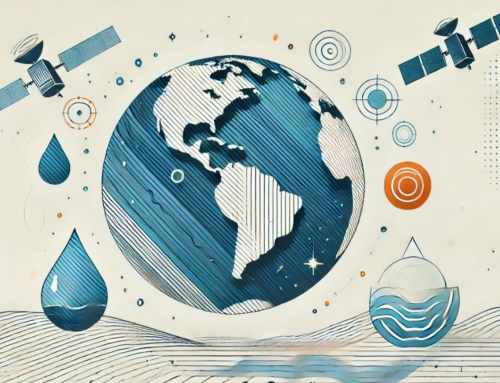
PROTECT project for agriculture, forestry, and other land uses
The goal of the PROTECT project is to enable public authorities to use state-of-the-art public procurement approaches in order to identify climate services based on Earth observation (EO) technologies that best fit the specific and systemic needs of the public sector. The focus of the project is on five application domains namely: Energy & Utilities, Sustainable Urban Communities, Agriculture, Forestry and Other Land Use, Marine and second Environments and Civil Security and Protection. This article provides an overview of the first application domain, Agriculture, Forestry and Other Land Uses, the key challenges within the sector, the existing market solutions and the emerging technological developments as well as some perspectives on the future of climate services for this sector, leveraging EO.
What is agriculture, forestry and other land uses?
Agriculture, forestry, and other land uses (AFOLU) covers an array of environments and encompasses great potential and need for climate services. Unsustainable use of agricultural and forest practices (e.g. overexploiting the soil, converting forests into agricultural land) create huge amounts of greenhouse gases and disrupt the already fragile equilibrium in the local ecosystems (GEF).
Using sustainable forest and land management practices with a view on long term and systemic impact can instead help those ecosystems retain and store significant amounts of carbon and preserve their fragile equilibrium.
The products of these sustainable practices could then fuel bioeconomy – a corollary of circular economy, where renewable biological resources from land and sea (such as crops, forests, fish, animals, micro-organisms etc.) are used to derive products, processes and services in all economic sectors within the frame of a sustainable economic system. (EC, Bioeconomy council).
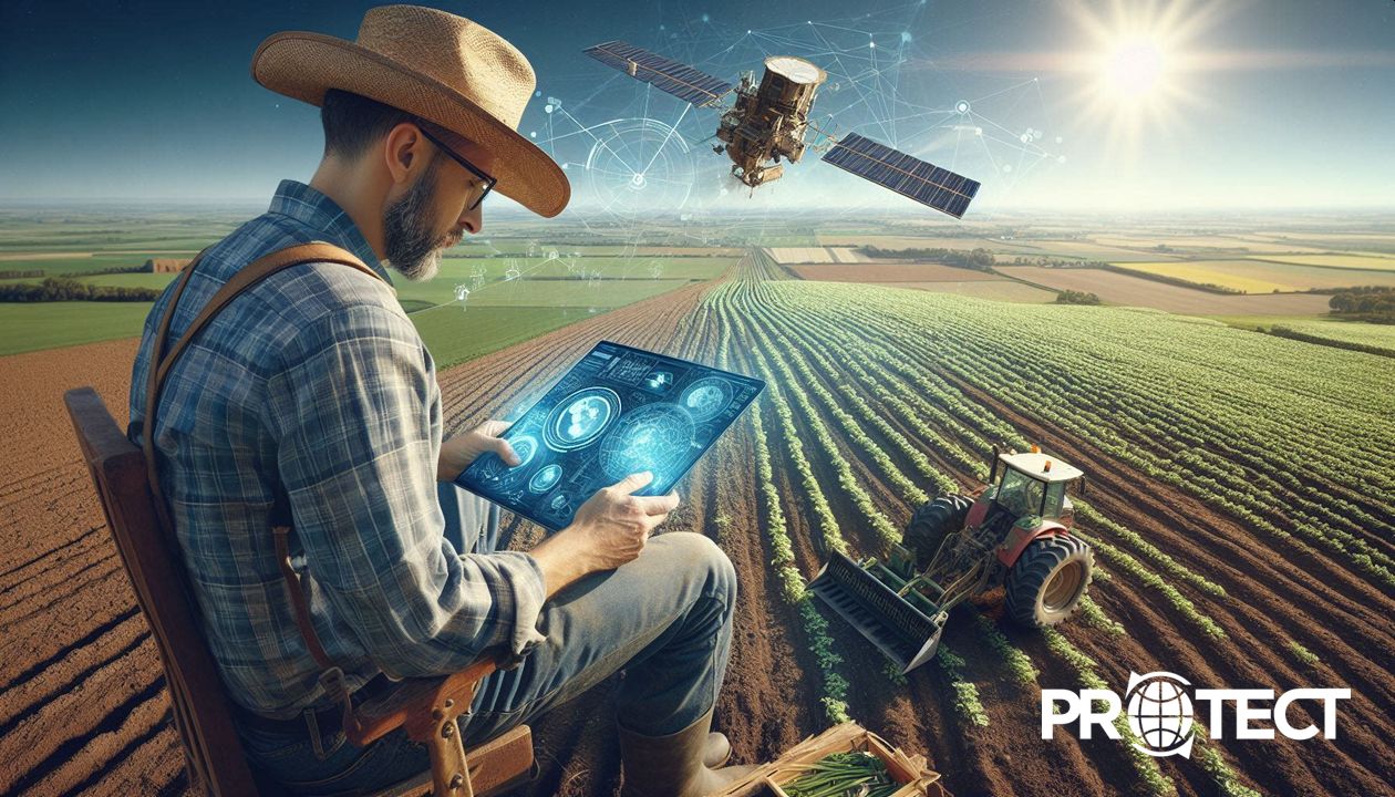
The role of Earth observation in Agiculture and Forestry
Climate services using Earth observation in the domain of AFOLU can contribute to a more optimised and sustainable exploitation of the land (based on precision agriculture, natural resources management) as well as counter the growing challenges related to the climate crises (i.e., providing forecasting and alerts on extreme weather events).
The AFOLU has a substantial impact on climate change, accounting for 23% of net global greenhouse gas (GHG) emissions and being the second largest emitting sector after energy . More widely, food system-related emissions, represent 34% of total GHG emissions per year, primarily comprising agriculture production and land-use activities (71%), with the remainder (29%) originating from other supply chain activities (retail, transport, consumption, etc.) . Due to substantive contribution to GHG emissions, the AFOLU sector is uniquely positioned to deliver significant climate mitigation benefits in a relatively low-cost and quick manner.
Nonetheless, the AFOLU sector is also directly influenced by the consequences of climate change, including severe weather phenomena that can result in significant harm to soil conditions, vegetation health, crop productivity and management of infrastructure associated with the sector. EO-based climate services play a crucial role in facilitating the monitoring solutions, aiming to safeguard and equip the sector for climate adaptation and the development of sustainable services for food security and environment protection.
The agriculture and forestry value chain
The value chain for the AFOLU sector represents the sequence of processes involved in field preparation and input supply, production, distribution and utilisation of agricultural and forest products, land sustainability and compliance aspects of agricultural, forestry, and other land-use activities.
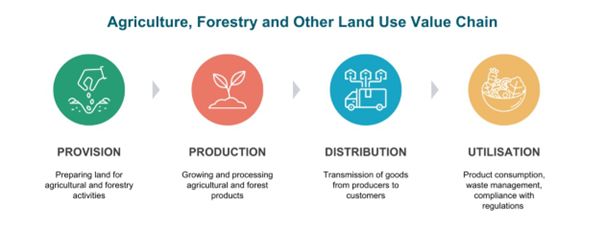 Figure 1: Agriculture, Forestry and Other Land Use – Value Chain
- Provision: This segment involves preparing the land for agricultural or forestry activities before sowing to ensure optimal plant growth, efficient resource utilisation, and contribution to sustainability of the land use. It includes functional zoning and infrastructure assessment, vegetation clearing, ground levelling, tilling, installation of irrigation systems, agro-climatic monitoring, soil enhancement, etc. This stage also involves the provision of inputs such as seeds, fertilisers, pesticides, machinery, and other resources necessary for production.
- Production: This segment represents the agricultural activities taking place in the field, including seed sowing, cultivating, soil conditions monitoring, fertilisation, irrigation, yield management, as well as rearing and livestock care. In forestry, this comprises tree growth and health control, biomass monitoring, disease and pest management, timber inventory and harvesting, wood and raw material generation, and so on.
- Distribution: This segment focuses on the development of efficient supply chains to connect producers with consumers of agricultural and forestry products. It involves activities such as logistics, transportation, infrastructure monitoring, storage, warehousing, etc.
- Utilisation: This segment pertains to the final stage of the value chain, including food consumption, wood for construction and manufacturing, bioenergy generation, and various other uses. It also presents practices for sustainable land management such as crop rotation planning, soil erosion control, biodiversity conservation, monitoring of greenhouse gas emissions etc., compliance with environmental regulations, and implementation of corrective measures to mitigate negative impacts.
It is important to note that the AFOLU value chain can vary significantly depending on regional contexts, and market dynamics. Different crops, livestock, forestry products, and land use practices have unique characteristics and may require specific arrangements.
Key challenges
In contrast to other sectors, the AFOLU can facilitate climate mitigation in several different ways. Specifically, it can reduce emissions as a sector in its own right, remove meaningful quantities of carbon from the atmosphere and relatively cheap, and provide raw materials to enable mitigation within other sectors, such as the energy industry or the built environment. However, the sector encounters several challenges in light of the climate adaptation, key of each are described below:
1 – Accounting of risks caused by natural phenomena and land use
Climate change brings increased variability and more frequent extreme weather events, such as droughts, floods, and shifts in temperature and precipitation, and as a result changing growing seasons that disrupt agricultural and forestry practices, impacting overall land productivity and sustainability. Moreover, the sector is closely associated with environmental problems caused by human activity, such as land degradation, soil erosion, deforestation, desertification, and biodiversity loss. Anthropogenic involvement directly affects more than 70% of the global, icefree land surface . Unsustainable land management, including intensive agriculture and improper forestry techniques, contribute to these issues, threatening ecosystem health and resilience. Therefore, the AFOLU sector must adapt its focus towards seeking remedies that deliver insights concerning meteorological circumstances and also ensure a persistent supply of information on spatial changes across designated areas of concern.
2 – Responding to food security threats
Observed climate change is already distressing food security through increasing temperatures, changing precipitation, and greater frequency of extreme events, and this trend is expected to continue in future. Particularly, changing weather patterns negatively affect crop yields in lower-latitude regions. Vulnerable pastoral and fruit and vegetable production systems are also at risk. Moreover, the problem of climate change driven land degradation is higher in pathways with a higher population, while urban expansion is projected to cause conversion of cropland leading to losses in food production that can result in additional pressure to the food system. As such, providing continuous and accurate information on weather patterns, along with reliable monitoring and early warning systems is crucial for the AFOLU sector to respond to the impacts of climate change on food security.
3 – Balancing increasing demands and environmental sustainability
According to recent statistics, the global demand for food is projected to increase by approximately 50% by 2050 . The demand for water is also anticipated to surge, with agricultural water consumption estimated to increase by 20-30% in the next two decades . Additionally, the production of biofuels is expected to rise significantly, with a projected annual growth rate of 6.2% between 2020 and 2027 . Sustainable intensification involves enhancing productivity without expanding agricultural land, reducing greenhouse gas emissions, and conserving natural resources. Striking a balance between the need for increased production and environmental preservation is vital to ensure long-term viability while minimising detrimental effects on ecosystems. As such, it is essential to provide accessible and comprehensive solutions that can analyse climate trends and timely environmental insights at both regional and local scales to predict how these changes will affect crop yield, and ultimately return on investment.
Existing Earth Observation Solutions
The combination and integration of space-based systems and terrestrial applications provide an increasing potential for customised solutions that have been developed to address the challenges of the AFOLU sector. Focusing on various thematic areas, the major Earth Observation (EO) technology developments followed by examples of project activities and innovative services for the AFOLU sector are described below.
Earth Observation Technologies
For the AFOLU sector, some of the major technological advancements in EO include the launch of meteorological and imaging satellites to collect weather and remote sensing data, the development of data processing algorithms using artificial intelligence (AI) and the creation of use-case specific, EObased climate services that are aimed at solving a particular problem within the sector.
The first major trend in EO impacting the AFOLU sector is the increasing number of launches of meteorological and imaging satellites. As of 2022, over 1,000 satellites in orbit are categorised as EO satellites, which includes those that monitor the land, the oceans and the atmosphere . One of the largest EO programmes in the world is the Copernicus programme from the European Commission, with an objective to monitor and forecast the state of the environment on land, sea and in the atmosphere. With a constellation of Copernicus Sentinel satellites, the data collected is then integrated with non-satellite sources to provide reliable and up-to-date information about six thematic areas. For the AFOLU sector, at least three of the thematic areas including land, atmosphere and climate change remain relevant .
The second major trend is the emergence of AI, which has a profound impact on the processing of data collected by satellites. With the explosion in the amount of data, it is important that only the useful subset data, for the AFOLU sector, is processed to provide actionable insights. As such, AI has a crucial role in the growth of the EO sector, specifically to convert the raw data collected by satellites into useful information.
The final trend is the growth in use-case specific climate services for forecasting applications. Data collected from satellites is processed with the help of AI and then integrated into climate solutions that solve a particular problem for the sector. An example of this, the Copernicus Climate Change Service (C3S) helps the sector plan for the future, increasing the efficiency of food production and improving food security with near real-time climate data, seasonal forecasts, past and future climate comparisons, and etc.
Climate services for agriculture and forestry
The following figure presents an overview of the EO-based climate services for the AFOLU sector. While it provides an expanded summary of services positioned on the value chain, this section will also detail some specific user case.
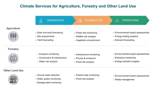
Figure 2: Agriculture, Forestry and Other Land Use – Climate Services
Here is a non-exhaustive list of 19 Earth Observation applications for agriculture, forestry, and other land uses, that re relevant for local authorities:
1 – Carbon capture and content assessment
Carbon capture and content assessment is an emerging technology that leverages EO-based remote sensing to monitor and assess carbon dioxide emissions and capture efforts. Satellites equipped with specialised sensors can provide valuable insights for understanding carbon emissions at a global scale . Remote sensing tools can measure carbon-storage efforts in isolated tracts of woods, offering a quicker, less costly way to count the benefits of carbon sequestration.
2 – Environmental impact monitoring
Environmental impact monitoring is crucial for assessing and managing the effects of human activities on the environment. It allows for accurate and timely assessment of land use changes by constructing a reference baseline from historical data and ongoing projects, including deforestation, desertification, pollution and contamination, habitat degradation, fragmentation, change in exposure to natural disasters, for example, flood and landslide, and so on .
3 – Biomass monitoring
Biomass is at present monitored using optical satellites, SAR and LiDAR technology, but it is still poorly quantified in most parts of the world having the global potential in understanding the carbon cycle and management of forests, biodiversity and ecosystems. The ALBIOM is an example of an innovative project that has been implemented to derive forest biomass using SAR Altimetry Data from the operating EU’s Copernicus Sentinel-3 Mission . A dedicated mission for biomass monitoring for carbon assessment is planned for launch in 2024 .
4 – Deforestation and degradation monitoring
Deforestation and degradation monitoring is vital for the AFOLU sector as it provides essential data on the extent and rate of forest loss, helping to identify areas at risk, inform conservation efforts, and promote sustainable land management practices. EO technologies are increasingly being used to monitor forest areas to reverse deforestation and degradation, providing global, comprehensive, and timely data to assess recent trends, support early detection, and monitor changes in forest cover and carbon stocks. The EU-funded REDD Copernicus project proposes a framework for a Copernicus REDD+ Service using the planned Copernicus Data and Information Access Services
Platform for improving accessibility and functionality . EO4SD-Forest is another example of ESA’s initiative which aims to support International Finance Institutions and their Client States with tailored EO-based information for Forestry Management decision making .
5 – Crop yield forecasting
Crop yield forecasting plays an important role for the AFOLU sector providing insights on resource allocation, market planning, and food security interventions based on projected harvests. Satellite imagery linked with process-based crop simulation models, machine learning, spatial indicators, and maps of crop production over different geographical locations is used to support predictions. The European Crop Monitoring System aims to provide a quantitative yield forecast at the national level for all major crops, as well as a bulletin reporting agro-meteorological conditions and a detailed analysis . Among other examples, ESA’s SMOS mission is used for droughts tracking and wheat crop yield prediction .
6 – Soil condition monitoring
Soil condition monitoring in the AFOLU sector involves the assessment of key parameters such as moisture content, nutrient levels, pH, and soil erosion. It enables farmers and land managers to optimise fertilisation, irrigation, and erosion control practices, leading to improved crop productivity and sustainable land management. As an example, ESA-funded WORLD SOILS project is designed to develop a pre-operational Soil Monitoring System for yearly estimations of Soil Organic Carbon at global scale, exploiting space-based EO data and leveraging large soil data archives and modelling techniques to improve the spatial resolution and accuracy of maps .
7 – Vegetation monitoring
Vegetation monitoring entails the observation and analysis of plant health, growth, coverage and biomass production. In agriculture, it aids in assessing crop conditions, detecting pests and diseases, optimising irrigation and fertilisation, and supporting sustainable land management practices. In forestry, multi-sensor EO and in situ data can be integrated to monitor changes in forest cover and carbon stocks, allowing for the implementation of a more complete measurement, reporting, and verification system for forest degradation and emissions.
8 – Forest inventory monitoring
EO-based forest inventory monitoring complements traditional field-based inventories, providing a broader and cost-effective perspective on forest dynamics. It offers valuable information for sustainable forest management, conservation planning, and climate change mitigation efforts. Satellite applications are used for reliable calculations and risk assessment, including forest gain and loss, insect outbreaks, woodland vegetation and regeneration maps, and consequences of forest fires and other natural events, as well as human activities.
9 – Forest vegetation health monitoring
Forest vegetation health monitoring enables a comprehensive and cost-effective assessment of forest condition at regional and global scales, providing critical information for forest management, biodiversity conservation, carbon accounting, and climate change mitigation strategies. By analysing the spectral data captured by satellites, valuable insights into the health, stress levels, disease and plagues and productivity of forests can be gained. The Forest Information System for Europe (FISE) is the first common database on forest information in Europe, offering tailor-made information generated with the use of Copernicus programme .
10 – Asset monitoring
Asset monitoring involves the continuous tracking and evaluation of various assets, such as agricultural machinery, forestry equipment, infrastructure such as irrigation systems and processing facilities, land and natural resources. It enables efficient asset utilisation, maintenance planning, and optimization of operations. By monitoring assets, stakeholders in the AFOLU sector can improve productivity, reduce downtime, and ensure the effective management of resources, ultimately leading to enhanced operational efficiency and profitability. As an example, ESA-funded Smart Geotechnical Asset Management (GSAM) service aims at offering an innovative and semi-automatic decision-making supporting system for asset management and predictive maintenance purposes, taking advantages of innovative data-fusion algorithms and satellite EO technologies .
11 – Common Agricultural Policy (CAP) monitoring
CAP monitoring is essential for the AFOLU sector as it enables compliance with agricultural regulations, supports the effective implementation, and facilitates the assessment of environmental and socio-economic impacts of agricultural practices. To ensure the success of the CAP, agricultural activities need to be monitored on a pan-European scale. Satellite imagery from the Copernicus program, provides a valuable tool for monitoring agriculture by combining high-resolution optical data with radar imagery and field-specific parameters. These applications go beyond the CAP requirements, which include crop classification, diversification, agricultural activities, and preservation of grassland and ecological focus areas . As an example, ESA-funded Sen4CAP project utilises satellite imagery along with in-situ data to generate valuable information for effective CAP implementation22.
12 – Pastureland management
Pastureland management involves implementing practices to optimise the productivity and health of grazing areas, ensuring sustainable forage production, promoting soil conservation, and supporting production in the AFOLU sector. EO-based climate services support pastureland management by optimising grazing strategies, assessing carrying capacity, and mitigating the effects of climate change on forage availability. As an example, the WORLDSOIL project, EO-based soil monitoring systems can be used to produce a final product that can cope with different spatial and temporal scales and support pastureland management.
13 – Precision irrigation
Precision irrigation sector implies advanced technologies, such as sensors and data analytics, to optimise water usage in agricultural and land-based activities of the AFOLU sector. By providing real-time information on soil moisture levels and crop water requirements, precision irrigation services enable targeted and efficient water application, conserving resources, maximising crop yield, and promoting sustainable water management practices. As an example, ESA-funded EOLO project is designed to help saving water and energy by predicting the optimal water needs and monitoring the crop health through satellitebased remote control of the irrigation systems .
14 – Variable rate application (VRA)
VRA refers to the process of applying inputs such as fertilisers, pesticides, or irrigation water at different rates within fields, based on the specific needs of different geographic areas. This approach aims to optimise resource usage and improve crop yields while minimising environmental impact. EO-based climate services play a crucial role in supporting VRA by providing valuable data and insights for decision-making. As an example, the EU Navigation Overlay Service can enable accurate and efficient VRA in agriculture, by combining different satellite technologies, including EO and GNSS .
15 – Forest asset management
Forest asset management encompasses strategic planning, monitoring, and utilisation of forest resources. It involves activities such as timber harvesting, reforestation, biodiversity conservation, and ecosystem services assessment. Effective forest asset management ensures sustainable consumption of forest products, economic viability, and environmental stewardship, contributing to the long-term sustainability of the AFOLU sector. By integrating EO data, forest managers can make informed decisions for sustainable forest management, conservation, and biodiversity preservation.
16 – Forest exploitation certification
Forest exploitation certification refers to the process of verifying and certifying sustainable and responsible forest management practices. It involves the assessment of factors like timber harvesting methods, environmental impact, social and economic considerations, and adherence to legal requirements.
Monitoring tools based on EO data help detect illegal logging activities, assess forest disturbances, and monitor reforestation efforts. By integrating EO-based climate services with certification processes, these services aid in promoting transparency, and contributing to the conservation of European forest ecosystems.
17 – Snow and ice monitoring
Snow and ice monitoring is crucial for the AFOLU sector as it provides essential information on land conditions, glaciers, and frozen ground in preparation for the growing season. In addition, this information helps in water resource management, flood prediction, and understanding the impacts of climate change on ecosystems. Near-real time climate services provide timely inputs on snow and ice covered regions, detect early and exact ice, and measure snow and ice thickness. In particular, radar remote sensing enables important data from snow and ice covered alpine and polar regions, which are difficult to access while optical imaging can be used to detect snow over land by accurately correcting for the atmosphere and identifying clouds, observing and monitoring ice extent over rivers and lakes, and monitoring snow cover.
18 – Climate services for agriculture
EO-based climate services for agriculture leverage satellite monitoring data to provide valuable insights into climate patterns and their impact on agricultural practices. Such services offer farmers information on long-term climate trends, seasonal variations, and extreme weather events. This data helps farmers anticipate and mitigate the effects of climate change, optimise crop selection and planting schedules, and implement appropriate adaptation strategies. Particularly, Copernicus Climate Change Service data help the agricultural sector plan for the future, increasing the efficiency of food production and improving food security.
19 – Weather forecasting for agriculture
Weather forecasting for agriculture enables timely and accurate predictions of weather conditions that directly impact farming activities. These services utilise meteorological data, satellite imagery, and advanced modelling techniques to forecast parameters like temperature, rainfall, humidity, wind speed, and solar radiation. By providing farmers with reliable weather forecasts, agricultural stakeholders can make informed decisions regarding irrigation, planting schedules, crop protection measures, and harvesting. This helps optimise resource management, minimise crop losses, increase productivity, and support sustainable agricultural practices in response to changing weather patterns.
Future Developments
As the EO market undergoes rapid progress with the continuously increased number of user cases, the volume of data obtained from satellites also steadily rises. Anticipated technological advancements encompass the expansion of sensors capable of detecting alterations on, above, or beneath the Earth’s surface. While there are several existing climate service solutions available for the AFOLU sector, it is important to understand the upcoming developments that might have an impact in the future.
The Copernicus programme is expected to see an evolution in the following years with the launch of the second generation of Sentinel satellites, which will cover hyperspectral imaging that can support environmental impact assessments, microwave imaging that can significantly enhance land management and environmental applications. Other missions include emissions monitoring satellites that will provide greenhouse emission reporting, thermal infrared imaging that can provide insights on the solar irradiation and site assessments, measurement of the world’s forest biomass and changes monitoring, assessment of the fluorescence emitted by plants which can indicate their photosynthetic activity and stress levels. This data will contribute to more accurate monitoring of vegetation health and enable improved agricultural practices . In addition, several commercial companies are also launching their own satellite constellations, which can complement data provided by public data sources with more frequent observations and enhanced accuracy.
In the future, it can be expected that satellite data will become highly democratised for use by end-users in the AFOLU sector. Therefore, organisations might choose to develop their climate services in-house as opposed to acquiring services from the market.
Conclusions
Climate change poses significant challenges to the AFOLU sector, with profound impacts on agriculture, forestry, and land use. Extreme weather events, changing precipitation patterns, and rising temperatures are affecting land productivity and causing serious concerns regarding sustainability of the environment. The AFOLU sector plays a critical role in global food security, making it imperative to develop climate-resilient practices, and prioritise investment in the development and adoption of innovative solutions to monitor and respond to changing environmental conditions. Addressing the impacts of climate change is crucial for ensuring the long-term viability and sustainability of the sector.
EO-based climate services tailored for the AFOLU sector are gaining momentum due to advancements in space technology and the increasing availability of satellite data. Satellites offer unique and scalable solutions for delivering actionable information, making them an invaluable source in the pursuit of sustainable development goals. As awareness and adoption of EO technologies grow, the market for climate services in the sector is poised for further expansion in the years ahead.