PROTECT Project for Civil Security and Protection
The goal of the PROTECT project is to enable public authorities to use state-of-the-art public procurement approaches in order to identify climate services based on Earth observation (EO) technologies that best fit the specific and systemic needs of the public sector. The focus of the project is on five application domains namely: Energy & Utilities, Sustainable Urban Communities, Agriculture, Forestry and other Land uses, Marine and Coastal Environments and Civil Security and Protection. This article provides an overview of the Civil Security and Protection application domain, the key challenges within the sector, the existing market solutions and the emerging technological developments as well as some perspectives on the future of climate services for this sector, leveraging EO.
Earth observation for civil security and protection
The Civil Security and Protection sector plays a significant role in addressing the climate change issues and ensuring the safety and well-being of communities. Extreme weather events, resulting from climate change, along with the impact of armed conflict on the environment and post-conflict recovery pose significant risks to the sector’s operations, security of people and critical infrastructures. Elevated temperatures, rising sea levels, desertification, water scarcity, biodiversity loss, environmental pollution, and disrupted livelihoods not only endanger the health and well-being of humanity but also have the potential to drive significant migratory movements, displacement, pandemics, social unrest, and overall instability and insecurity in societies.
Application domain profile
The UN estimates that since 2008 an annual average of 21.5 million people have been forcibly displaced by weather-related events, such as floods and heatwaves. These numbers are expected to increase in the coming decades, exacerbating demographic change and putting stress on cities and urban areas where the demand for housing, food, energy and jobs may rise, thus contributing to increasing social impacts of climate change . It is projected that by 2050 more than one billion people will have insufficient access to water, that soil degradation could rise to 90%, while demand for food could increase by 60% .
In this context, climate services offered through EO technologies are crucial for civil security and protection in adapting to the challenges posed by climate change. By incorporating these services, the sector can enhance its preparedness, response, and recovery capabilities, safeguarding lives, critical infrastructure, and the environment.

The civil security and protection value chain
The Civil Security and Protection sector value chain represents several activities and policies that contribute to the overall functioning and effectiveness, ensuring the safety, security, and protection of individuals, communities, and infrastructure. Due to the significant diversity and varying organisational structures across different geographical regions, the following segmentation provides a high-level overview.
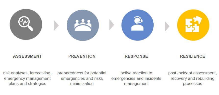
Figure 1: High-Level Value Chain of the Civil Security and Protection Sector
- Assessment: This segment involves measuring potential risks and threats to societal security, conducting risk analyses, forecasting, and developing comprehensive emergency management plans and strategies. It encompasses activities such as identifying hazards, evaluating vulnerabilities, monitoring the impact of human activities, predicting and planning migration and settlement caused by climate change. Policies are implemented to ensure that governments and organisations prioritise risk assessment, establish standardised methodologies, and regularly update emergency management plans in accordance with changing threats.
- Prevention: This segment is dedicated to proactive measures aimed at preparedness for potential emergencies and risks minimization. It includes providing training and necessary equipment to emergency response teams, conducting practice drills and exercises, implementing early warning systems, raising public awareness and education on safety and security measures. Policies are established to enforce mandatory safety protocols and allocate resources for preventive measures, ensuring that proactive steps are taken to avoid emergencies and enhance readiness.
- Response: This segment covers active reaction to emergencies and overall management of incidents as they unfold. It entails various activities, including coordinating emergency operations, facilitating communication, managing command centres, mobilising and allocating resources, conducting search and rescue operations, and prioritising the safety and well-being of affected individuals. Policies play a crucial role in this segment by guiding the establishment of emergency response frameworks, fostering interagency coordination mechanisms, and implementing protocols for effective communication to ensure a rapid and well-coordinated response, safety and security of those affected by emergencies and critical situations.
- Resilience: This segment pertains to the post-incident phase and focuses on the recovery and rebuilding processes. It includes damage assessment, restoration of critical infrastructure and services, resettlement for affected communities, insurance and long-term resilience building measures. Policies are enacted to guide the recovery efforts, allocate funding for reconstruction, establish support systems, and integrate resilience-building measures into the rebuilding process.
Key challenges
While the Civil Security and Protection sector itself does not directly contribute to climate change, it faces substantial challenges associated with the impacts and consequences of the changed weather patterns, key of each are described below.
- Situational awareness and rapid response in extreme weather events. With the increasing frequency and intensity of climate change-driven events such as hurricanes, floods, heatwaves, and wildfires, the Civil Security and Protection sector faces the critical task of taking timely actions to protect lives and mitigate damages. Such phenomena cause significant challenges for the sector, as they require effective emergency response, evacuation planning, and the management of resources. However, achieving enhanced situational awareness can be challenging due to the need for real-time and continuous weather information, damage assessment and integration of early warning systems. According to the Global Commission on Adaptation, giving just 24 hours’ notice of an impending hazardous event can reduce damage by 30 percent. Meeting this challenge requires reliable real-time data sources, advanced monitoring technologies and data analytics to provide decision-makers with accurate and actionable insights.
- Evaluating climate impacts on security operations. Security operations, including national defence and military campaigns, are significantly affected by various climatic hazards, such as extreme weather events, rising sea levels, and changing temperature. They pose direct threats to strategic environment, assets and installations, missions and multi domain operations, resilience and civil preparedness. These impacts can hinder the readiness, mobility, and effectiveness of military forces. The need for enhanced resilience and adaptive capabilities becomes crucial as security operations must contend with unpredictable and intensified climatic conditions. These complex challenges demand strategic planning and the integration of climate considerations into defence policies. Hence, the sector needs to explore solutions that not only deliver real-time weather information but also ensure continuous coverage, and integration of climatological data enabling effective mitigation of climate impacts and enhancing operational resilience.
- Addressing climate change induced insecurity. Security concerns linked to climate change include impacts on food, water and energy supplies and increased competition over natural resources. Livelihoods are at risk, especially in exposed communities reliant on climate-sensitive sectors like agriculture and energy, leading to economic instability. Extreme weather events cause substantial infrastructure damage contributing to forced migration and displacement, which can escalate social problems at local and international levels, including resource conflicts, social unrest, and geopolitical tensions. In addition, environmental factors affect energy supplies to both civilian and military domains. Natural disasters can damage or disrupt infrastructure and pose risks to energy security. Restoration and resilience-building efforts become vital in the face of climate-induced damage. As such, climate services can aid in resolving this challenge by providing crucial data and insights for proactive risk assessment and planning, enabling effective response and preparedness to mitigate the impacts of climate change-induced insecurity.

Existing Market Solutions
The combination and integration of space-based systems and terrestrial applications provide an increasing potential for customised solutions that have been developed to address the challenges of the Civil Security and Protection sector. Focusing on various thematic areas, the major EO technology developments followed by specific examples are described below.
EOTechnologies
For the Civil Security and Protection sector, some of the major technological advancements in EO include the launch of meteorological and imaging satellites to collect weather and remote sensing data, the development of data processing algorithms using artificial intelligence (AI) and the creation of usecase specific, EO-based climate services that are aimed at solving a particular problem within the sector.
The first major trend in EO impacting the civil security and protection domain is the increasing number of launches of meteorological and imaging satellites. As of 2022, over 1,000 satellites in orbit are categorised as EO satellites, which includes those that monitor the land, the oceans and the atmosphere. One of the largest EO programmes in the world is the Copernicus programme from the European Commission, with an objective to monitor and forecast the state of the environment on land, sea and in the atmosphere. With a constellation of Copernicus Sentinel satellites, the data collected is then integrated with non-satellite sources to provide reliable and up-to-date information about six thematic areas. For the Civil Security and Protection sector, at least four of the thematic areas including security, emergency, climate change and land remain relevant.
Among meteorological missions, EUMETSAT’s Meteosat, which has been an invaluable data source for weather forecasting since 1977, has introduced the Third Generation with the launch of the most innovative weather satellite for the early detection and prediction of fast-developing severe storms, weather forecasting and climate monitoring. Another European programme MetOp has improved its accuracy, including extending short-term forecasts by one day.
The second major trend is the emergence of AI, which has a profound impact on the processing of data collected by satellites. With the explosion in the amount of data, it is important that only the useful subset data, for the Civil Security and Protection sector, is processed to provide actionable insights. As such, AI has a crucial role in the growth of the EO sector, specifically to convert the raw data collected by satellites into useful information.
The final trend is the growth in use-case specific climate services for the Civil Security and Protection. Data collected from satellites is processed with the help of AI and then integrated into climate solutions that solve a particular problem for the sector. An example of this, the Copernicus Climate Change Service (C3S) provides climate information to support policies related to disaster risk reduction, as well as practices to address weather-related risks.
Climate Services for Civil Security and Protection
The following figure presents an overview of the EO-based climate services for the Civil Security and Protection sector. While it provides an expanded summary of services positioned on the value chain, this section will also detail some specific user case.
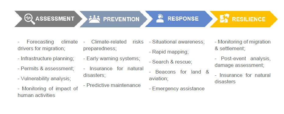
Figure 2: Examples of Climate Services for the Civil Security and Protection Sector
The following are 9 examples of Earth observation solutions for climate-related civil security and protection challenges:
1 – Early warning systems
combine forecasting, monitoring, and alert services to provide timely and accurate information about potential hazards. These systems use EO data, weather forecasts, and monitoring technologies to analyse and predict floods, wildfires, storms, and other climate-related risks. In particular, a European-wide weather alert system coordinated by EUMETNET provides real-time severe weather warnings and forecasts for various hazards, including storms, heavy rainfall, extreme temperatures, and strong winds. European Flood Awareness System uses a combination of weather forecasts, hydrological models, and satellite-based observations to monitor river levels and predict floods. Emergency and Disaster Information Service enables access to real-time information on natural disasters, industrial accidents, and public health threats and aiming to facilitate the rapid exchange of information and support coordination among civil protection authorities and organisations.
2 – Monitoring and forecasting migration and settlement
EO-based climate services play a crucial role in understanding and addressing the climate impact on human migration and settlement dynamics. Satellite imagery and data from meteorological sensors are used to analyse climate conditions in areas prone to migration. By examining temperature, precipitation, vegetation health and water conditions, regions experiencing climate-related changes driving migration patterns can be identified. Also, EO-based climate services contribute to forecasting climate drivers for migration. By integrating climate change models, and projections, these services can anticipate future climate scenarios and associated risks, such as extreme weather events, sea-level rise, or prolonged droughts. Such forecasts enable policymakers and stakeholders to anticipate potential migration patterns and plan for adaptation and resilience measures accordingly.
As an example, European Centre for Medium-Range Weather Forecasts utilise satellite observations as part of broader climaterelated research and monitoring activities alongside other climate-related datasets to gain insights into climate change dynamics, weather patterns, and environmental conditions.
3 – Post-event analysis
EO technologies are used to conduct detailed assessments of climaterelated events, including the extent of damage, changes in land cover, infrastructure and assets, or impacts on vegetation health, and provide valuable insights into the aftermath of disasters, facilitating informed decision-making for response planning, resource allocation, and targeted recovery efforts.
As an example, Copernicus Emergency Management Service offers rapid mapping and monitoring products that utilise EO data to assess and analyse the impacts of natural and man-made disasters, including earthquake monitoring, flood mapping, and wildfire analysis, contributing to effective post-event analysis and decision-making in civil security and protection.
4 – Climate Risk Preparedness
Climate services for preparedness represent a range of capabilities aimed at enhancing readiness and response to climate-related risks, supporting the Civil Security and Protection sector in adapting for and mitigating the impacts of climate change, strengthening resilience, and ensuring effective response measures are in place to protect lives, infrastructure, and the environment. EO data is applied to provide insights on climate patterns, extreme weather events, and environmental changes. Stakeholders can assess vulnerability, identify high-risk areas, and develop targeted preparedness strategies, including early warning systems, contingency planning, resource allocation, and training programs. As an example, Copernicus Emergency Management Service provides various tools and services that utilise EO data for risk assessment and planning, offering hazard maps, vulnerability assessments, and early warning systems to support proactive preparedness efforts.
5 – Rapid mapping
Rapid mapping services involve the prompt and accurate assessment and mapping of climate-related events and their impacts. Satellite imagery, information from meteorological satellites and other climate data sources, fusion algorithms and enhanced geoinformation tools are utilised to provide insights on the extent of damage, changes in land cover, and other critical factors following natural disasters or emergencies. In particular, The European Rapid Mapping Service is a part of the Copernicus Emergency Management Service. It provides geospatial information within hours from activation.
6 – Search and rescue
Climate services for search and rescue leverage EO data and beacon technologies to enhance situational awareness, support efficient response coordination, and improve the effectiveness of operations in both aviation and land-based contexts.
- Beacons for aviation: In the aviation sector, climate services utilise beacons that transmit distress signals in case of emergencies. These beacons, such as Emergency Locator Transmitters (ELTs) and Personal Locator Beacons (PLBs), provide a critical tool for locating downed aircraft and individuals in remote or hazardous environments. By integrating climate data, weather forecasts, and satellite communication, these beacons assist in improving the chances of successful SAR operations.
- Beacons for land: Similarly, climate services include the use of beacons for landbased SAR operations. These beacons, such as Personal Locator Beacons (PLBs), satellite tracking devices, or Emergency Position Indicating Radio Beacons (EPIRBs), allow individuals in distress to transmit their location to SAR teams. These beacons enhance the speed and accuracy of locating individuals in need of rescue, particularly in challenging terrain or adverse weather conditions.
- Situational awareness supporting search and rescue: Climate services also incorporate situational awareness tools that utilise Earth observation data and satellite imagery. These tools provide real-time monitoring of weather conditions, terrain, and other environmental factors relevant to SAR operations. By integrating these data sources with SAR protocols and navigation systems, search and rescue teams gain improved situational awareness, enabling them to plan and execute operations more effectively.
For example, an EU initiative Galileo Search and Rescue Service integrates GNSS with SAR capabilities, incorporates distress beacons which can transmit distress signals and location data to SAR authorities enhancing the accuracy and efficiency of operations in Europe.
7 – Infrastructure Planning
Climate services for infrastructure planning involve the use of geospatial data to enhance the resilience of infrastructure systems.
- Permits and assessment: EO data is applied to assess the environmental impact and suitability of infrastructure projects. Coupled with geospatial information, they support permit applications, environmental impact assessments, and land-use planning providing insights into factors such as topography, land cover, vegetation, and hydrological conditions, and enabling more informed decisions regarding the location and design of infrastructure.
- Vulnerability analysis: By integrating meteorological data, remote sensing, and modelling techniques, climate services can assess the vulnerability of infrastructure assets to various climate-related hazards, such as sea-level rise, extreme weather events, and changes in temperature or precipitation patterns. This analysis enables identification of critical infrastructure at risk, prioritisation of adaptation measures, and development of resilient strategies to minimise potential impacts.
As an example, ESA’s Urban Thematic Exploitation Platform (U-TEP) utilises high-resolution satellite imagery and aerial photography, to aid in permits and assessment processes for infrastructure projects. Also, it and combines remote sensing, and geospatial data to assess the exposure, vulnerability, and resilience of infrastructure systems to climate-related risks.
8 – Insurance for natural disasters
encompasses applications that utilise EO data, to assess and manage risks associated with natural disasters. These services are instrumental in providing insights to insurance companies, enabling them to effectively evaluate and mitigate the potential impacts of climate-related events on insurance portfolios. By analysing EO data, stakeholders can assess the likelihood and severity of natural disasters, evaluate the vulnerability of specific areas or properties, and estimate potential financial losses. Meteorological satellites provide real-time and high-resolution data on weather patterns, atmospheric conditions, and climate variables, enabling accurate risk assessment and forecasting. Furthermore, EO data can support claims management processes by providing before-and-after imagery of affected areas, aiding in the assessment of damages and expediting the claims settlement process. In addition, EO-based climate services facilitate the identification of high-risk areas and help insurance companies tailor their products and premiums, address specific climate-related risks and enhance risk modelling by providing accurate and up-to-date information on climate conditions, environmental factors, and trends to assess the likelihood and potential severity of natural disasters.
As an example, ESA’s Climate Change Initiative on Essential Climate Variables (ECVs) provides long-term, quality-controlled EO datasets for various ECVs, such as sea surface temperature, sea level, and land cover. Insurance companies can utilise these services to assess the risks associated with climate change, including changes in sea levels, extreme weather events, and land use patterns by incorporating them into their risk modelling systems.
9 – Critical infrastructure
EO-based climate services for critical infrastructure combine a wide range of applications aimed at supporting the construction, monitoring, maintenance, and emergency response of infrastructure systems to provide valuable insights and information for various stages of critical infrastructure lifecycle management.
- Construction operations: high-resolution satellite imagery, aerial photography and climatological statistics are essential data sources for site selection, planning, and design purposes. They enable identification of suitable locations, assessment of terrain conditions, and visualisation of the surrounding environment to ensure optimal construction practices.
- Monitoring the impact of human activities on infrastructure enables the detection and assessment of changes on infrastructure systems. By analysing historical information on land use, urbanisation, and environmental invasions, authorities can assess potential risks and vulnerabilities to infrastructure systems. Land cover maps and population density data contribute to understanding the human impact on infrastructure and inform decision-making for protection measures.
- Infrastructure monitoring: EO facilitates continuous monitoring of infrastructure, including transportation networks, power grids, water resources, and communication systems. By integrating data from meteorological satellites and other sources, stakeholders can control the condition, performance, and resilience of infrastructure, enabling timely maintenance, early detection of anomalies, and timely response to potential failures or disruptions.
- Predictive maintenance: by leveraging EO data, such as thermal imagery, vegetation indices, and structural monitoring, operators can detect anomalies, identify potential failures, and schedule maintenance activities proactively. Integrating meteorological data enhances the understanding of climate-related risks, allowing for weatherdependent maintenance planning and reducing the likelihood of disruptions. This proactive approach helps optimise schedules, reduce downtime, and enhance the overall reliability of infrastructure systems.
- Emergency assistance and design of infrastructure: During emergencies, spaceenabled climate services provide rapid mapping and situational awareness, aiding in damage assessment, resource allocation, and the coordination of emergency services. Geospatial sources provide analysis and insights into flood-prone areas, seismic zones, and other hazard-prone regions, guiding the design of infrastructure that can withstand climate-related risks within hours.
As an example, the above-mentioned ESA’s U-TEP platform utilises EO data to support the monitoring and management of critical infrastructure in urban areas. Furthermore, the EU’s INSPIRE Directive promotes the use of EO data and other geospatial information for infrastructure monitoring and management. It aims to facilitate the exchange of geospatial data among European countries to support the effective monitoring, assessment, and planning of critical infrastructure.
Future Developments
As the EO market undergoes rapid progress with the continuously increased number of user cases, the volume of data obtained from satellites also steadily rises. Anticipated technological advancements encompass the expansion of sensors capable of detecting alterations on, above, or beneath the Earth’s surface. While there are several existing climate service solutions available for the Civil Security and Protection sector, it is important to understand the upcoming developments that might have an impact in the future.
The Copernicus programme is expected to see an evolution in the following years with the launch of the next generations of Sentinel satellites, designed to expand the current capabilities and address EU policy and user needs, including natural disasters, and climate change. New satellites LSTM, CRISTAL and ROSE-L will be launched as of 2027 to expand the current capabilities in key areas such as food security, irrigation and water scarcity. Other missions are expected to bring new sensors to provide valuable data for addressing security and protection challenges, aiming to improve situational awareness and support decision-making processes.
Among meteorological missions, the Meteosat Third Generation will enable access to critical data for short-term and early detection of potential extreme weather events over the next 20 years. Metop-SG mission will further improve weather forecasting and climate research, using 10 different instruments, covering ultraviolet, visible, infrared and microwave spectral bands.
In future, it can be expected that satellite data will become highly democratised for use by end-users in the sector. Therefore, organisations might choose to develop their climate services in-house as opposed to acquiring services from the market.
Conclusions
The Civil Security and Protection sector is confronted with significant challenges as climate change leads to a rise in the frequency and intensity of extreme weather events, posing threats to infrastructure, societal well-being, and security. To tackle these challenges, EO-based climate services provide a valuable solution by improving preparedness, facilitating risk assessment, and enhancing decisionmaking processes, enabling the sector to effectively respond to and mitigate the impacts of climaterelated events. By leveraging satellite imagery, meteorological information and advanced geospatial technologies, these services provide crucial information for monitoring and readiness to changing environmental conditions, ensuring the long-term viability and resilience of critical infrastructure and safeguarding the safety and well-being of communities.
As space technology continues to evolve and satellite data becomes more accessible, EO-based climate services in the Civil Security and Protection sector are experiencing a growing demand and increasing recognition. Satellites offer scalable and actionable solutions, enabling authorities to effectively address the impacts of climate change, optimise resource allocation, and enhance the sector’s capacity to respond to emergencies. As the awareness and adoption of EO technologies grow, the market for climate services in the sector is expected to expand further, leading to increased resilience, improved decision-making, and a more sustainable approach to protecting societies and critical infrastructure in the face of climate-related challenges.